Bathymetry training is a crucial component in enhancing disaster preparedness and managing Glacial Lake Outburst Flood (GLOF) risks, particularly in regions like Arunachal Pradesh. Recently, the Arunachal Pradesh State Disaster Management Authority (APSDMA) hosted a comprehensive three-day training program focused on the use of bathymetry survey devices. With 32 high-risk glacial lakes identified in the area, this training aims to equip local authorities and specialists with the skills needed to conduct effective surveys, ultimately safeguarding downstream communities and infrastructure from potential flooding threats. The initiative forms part of a broader strategy to mitigate the increasing peril posed by these lakes through more precise monitoring and risk assessment techniques. By embracing modern bathymetric technologies, participants are prepared to tackle the pressing challenges associated with glacial lake dynamics and GLOF mitigation, ensuring a safer future for residents of Arunachal Pradesh.
The hands-on program in Arunachal Pradesh highlights the significance of hydrographic surveys in assessing the risks posed by glacial water bodies. This educational effort is essential for enhancing the capabilities of disaster management professionals, particularly regarding the monitoring of flood-prone glacial lakes. In light of the increasing threat of GLOF events, upgrading skills related to lake bathymetry becomes imperative for effective response strategies. By utilizing bathymetry tools and methodologies, participants can gather critical data that will inform risk management and disaster response plans. Ultimately, this initiative focuses on empowering local stakeholders to better understand hydrological changes and implement proactive measures against potential flood disasters.
The Importance of Bathymetry Training in Disaster Preparedness
Bathymetry training plays a crucial role in enhancing disaster preparedness, particularly in regions susceptible to glacial lake outburst floods (GLOFs). In Arunachal Pradesh, where the landscape is dotted with high-risk glacial lakes, the ability to effectively conduct bathymetric surveys is vital. Through the insights gained during the training, officials can better monitor lake volumes, assess sediment loads, and evaluate the overall stability of these glacial bodies. This data is fundamental for developing risk management strategies that can significantly mitigate the impacts of potential flooding incidents on downstream communities, infrastructure, and the environment.
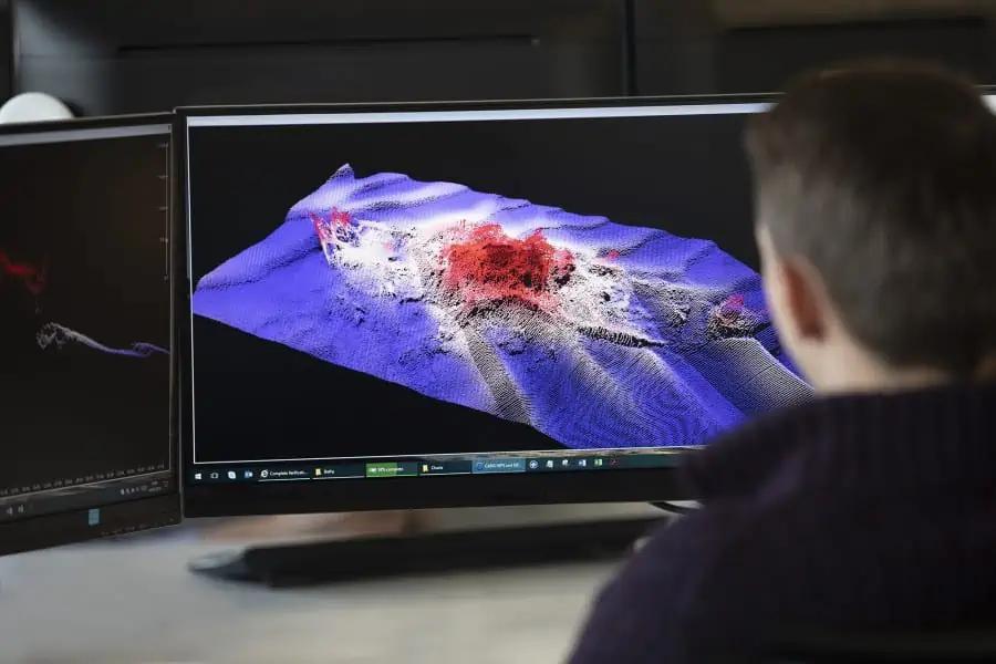
Moreover, the training program emphasizes the importance of using advanced bathymetry survey devices, as these tools provide critical data that assists in the identification of potentially hazardous lakes. According to experts, understanding the morphology and depth of glacial lakes is essential for disaster planning and response. The hands-on experience gained by participants in the field, particularly through practical exercises at Ganga Lake, equips them with the necessary skills to conduct meaningful surveys and analyses. As climate change continues to affect the dynamics of glacial lakes, consistent training in bathymetric techniques remains crucial for safeguarding Arunachal Pradesh’s vulnerable populations.
GLOF Risk Management and Bathymetric Surveys
Effective GLOF risk management hinges on the depth of knowledge that comes from comprehensive bathymetric surveys. In Arunachal Pradesh, authorities are acutely aware of the risks posed by their numerous glacial lakes, which have been increasing in size. During the recent training spearheaded by the Arunachal Pradesh State Disaster Management Authority (APSDMA), various technical aspects of bathymetry were covered, showcasing the importance of accurate data collection for understanding potential flood risks. By utilizing bathymetry survey devices, data on glacial lake volumes can be accurately measured, leading to better predictions of lake behavior and GLOF occurrences.
This strategic approach also integrates multiple stakeholders, including the Geological Survey of India and other disaster management organizations, highlighting the collaborative efforts needed to address the GLOF threat comprehensively. The training underscores that through consistently improving database resources and analytical methods provided by bathymetric surveys, Arunachal Pradesh can devise effective early warning systems and response strategies. Such proactive risk management measures not only protect communities from imminent threats but also foster a culture of preparedness that is essential in coping with climate-related disasters.
Advancements in Bathymetry Survey Technology
The field of bathymetry is continually evolving, with new technological advancements enhancing the capabilities of survey devices. During the training conducted in Arunachal Pradesh, participants were exposed to cutting-edge tools designed for more efficient data collection and analysis. These innovations allow for better accuracy in capturing underwater topography, which is vital when assessing glacial lakes that are under threat of flooding. The integration of modern survey technology into risk management strategies ensures that data is not only collected but also processed in a manner that is timely and relevant to disaster response efforts.
Furthermore, advancements in remote sensing and underwater mapping technology have revolutionized how glacial lakes are monitored. The training course illustrated how these new capabilities can facilitate detailed assessments, enabling trained personnel to conduct more thorough evaluations of lake risks and vulnerabilities. With Arunachal Pradesh identified as having several high-risk glacial lakes, these technological enhancements are paramount in supporting ongoing research and preventative measures. The ability to adapt to and incorporate new technologies into bathymetric training ensures that disaster management efforts remain effective against evolving environmental challenges.
Collaboration Among Various Disaster Management Agencies
The successful implementation of bathymetry training in Arunachal Pradesh highlights the significant collaboration needed among various disaster management agencies. Involving stakeholders like the India Meteorological Department (IMD) and the Geological Survey of India (GSI) ensures that a multi-faceted approach is taken when addressing the risks associated with glacial lakes. The combined expertise of these organizations enhances the overall effectiveness of GLOF risk management strategies by providing a richer pool of data and insights into the behaviors of high-risk lakes.
Joint training initiatives can help foster a shared understanding of disaster preparedness strategies while instilling a sense of unity in the response efforts to GLOF threats. Each agency brings unique capabilities to the table, and their collaboration during the bathymetric training sessions strengthens regional capacity building. As they work hand-in-hand to monitor and analyze glacial lake conditions, emergency preparedness improves, leading to timely responses and potentially life-saving interventions for communities in the path of a possible outburst flood.
Field Training Importance for Practical Knowledge
Field training sessions, such as those held at Ganga Lake during the bathymetry training workshop, are invaluable in providing participants with practical knowledge that complements theoretical teachings. Real-world experiences enable trainees to directly engage with the equipment and gather data in the field, reinforcing the lessons learned during classroom sessions. This hands-on training empowers disaster management professionals to apply their newfound skills immediately, which is critical for timely and effective response in real situations where glacial lake flooding might occur.
Additionally, field training allows for the direct observation of varying conditions that can affect bathymetric measurements — such as water clarity, depth variations, and lake morphology. This concrete experience offers a deeper appreciation of how to assess risks accurately and design mitigation strategies that account for the specific characteristics of glacial lakes in Arunachal Pradesh. Through consistent field training, participants become adept at operating bathymetric survey devices, ensuring that they can efficiently contribute to disaster recovery efforts in the case of GLOFs.
The Role of Bathymetric Data in Flood Mitigation
Bathymetric data is essential in shaping effective flood mitigation strategies, particularly in areas susceptible to glacial lake outburst floods. In Arunachal Pradesh, the collection and analysis of this crucial data allow authorities to understand the volume and behaviors of glacial lakes, enabling informed decision-making concerning disaster response protocols. Such data helps predict potential flooding events, ensuring that communities downstream are appropriately warned and can evacuate if necessary, demonstrating the proactive measures taken to safeguard lives and infrastructure.
Moreover, by integrating bathymetric data into regional planning efforts, local agencies can identify priority areas for risk reduction interventions. This information is key for designing infrastructure that can withstand possible flood events, such as reinforced roads and embankments, or implementing effective drainage systems. Furthermore, as climate change continues to impact the frequency and severity of glacial lake floods, ongoing monitoring through bathymetric surveys becomes even more critical in adapting to these new realities. The reliance on accurate bathymetric data strengthens overall disaster preparedness in Arunachal Pradesh, ultimately reducing the GLOF risk for vulnerable populations.
Strengthening Community Awareness and Preparedness
Community awareness and preparedness are vital components of an effective disaster risk management strategy, particularly in regions vulnerable to glacial lake outburst floods. Training initiatives, such as the recent bathymetry program in Arunachal Pradesh, not only enhance technical skills among professionals but also serve as a platform for raising awareness about the risks faced by local populations. Engaging communities in discussions about GLOF threats can lead to increased vigilance and preparedness measures that can significantly mitigate the impact of potential flooding.
Moreover, as professionals equipped with knowledge from the bathymetric training collaborate with local communities, they can better inform residents about the signs of impending floods and the necessary steps to take in an emergency. This proactive communication helps build resilient communities that are prepared to respond adequately during crises. Ultimately, strengthening community awareness through partnerships between disaster management authorities and local residents will lead to a more comprehensive approach in addressing the threats posed by glacial lake floods.
The Future of Bathymetry in Disaster Management
As disaster risks escalate due to climate change, the role of bathymetry in disaster management will become increasingly crucial. The training conducted in Arunachal Pradesh is just one example of how authorities are recognizing the importance of integrating bathymetric surveys into their comprehensive disaster response strategies. With ongoing advancements in technology and data analysis, bathymetric studies are set to provide more accurate and timely insights into the conditions of glacial lakes, thus better informing risk management efforts.
The future of bathymetry in disaster management will also involve enhanced collaboration between various organizations and communities, ensuring that knowledge is shared and applied effectively in addressing GLOF threats. Such initiatives will empower local authorities to take ownership of disaster preparedness measures and tailor them according to the unique challenges presented by their specific geographic and climatic conditions. As the field further develops, the emphasis on training and technical expertise will undoubtedly play a significant role in shaping resilient communities against disasters in high-risk areas like Arunachal Pradesh.
Frequently Asked Questions
What is bathymetry training and why is it important for GLOF risk management in Arunachal Pradesh?
Bathymetry training involves educating personnel on the use of bathymetry survey devices to assess underwater features and depths of bodies of water. In Arunachal Pradesh, this training is crucial for GLOF risk management as it helps identify and monitor high-risk glacial lakes that could potentially trigger Glacial Lake Outburst Floods (GLOFs). Implementing effective bathymetric surveys enhances disaster preparedness by providing vital data that supports timely interventions and infrastructure protection for vulnerable communities.
| Key Point | Details |
|---|---|
| Training Overview | A three-day hands-on training program was conducted by APSDMA in Itanagar focusing on bathymetry survey devices. |
| Purpose | The training aimed to strengthen disaster preparedness and manage GLOF risks in Arunachal Pradesh. |
| Risk Areas | 32 glacial lakes in Arunachal Pradesh identified as high-risk for triggering GLOF events. |
| Training Sessions | Included theoretical sessions on technical operations of bathymetry devices and practical demonstrations at Ganga Lake. |
| Participants | Attendance included officials and experts from IMD, GSI, APSAC, and various Disaster Management Authorities. |
| Importance of Bathymetric Surveys | Surveys crucial for assessing threats from glacial lakes and developing mitigation strategies. |
Summary
Bathymetry training conducted in Arunachal Pradesh is pivotal for professionals engaged in managing risks associated with glacial lakes. This training initiative not only enhances technical skills in bathymetric survey operations but also plays a crucial role in disaster preparedness strategies. Given the increasing number and size of glacial lakes posing threats to local communities, the program aims to equip local agencies with the necessary tools and knowledge to assess these risks effectively. By fostering collaboration among various departments and using modern survey techniques, the training supports the state’s long-term strategy to mitigate potential Glacial Lake Outburst Floods (GLOFs), thereby safeguarding lives and infrastructure.