The Gagan satellite navigation system represents a significant milestone in India’s advancement in aviation and navigation technology. As the first SBAS certified for the equatorial region, Gagan positions India alongside other global leaders in GPS navigation technology. Developed jointly by the Airports Authority of India (AAI) and the Indian Space Research Organisation (ISRO), this innovative system enhances the accuracy and reliability of satellite-based navigation for various applications, primarily in the aviation sector. By reinforcing India’s commitment to technological self-reliance, Gagan has become pivotal in ensuring safe and efficient air travel while also supporting diverse fields such as maritime navigation and telecommunications. With its impressive capabilities, Gagan not only improves operational safety but also marks a new era for India in satellite navigation landscape, showcasing the country’s growing prowess in this critical area of technology.
Known as India’s state-of-the-art satellite-based augmentation system, Gagan symbolizes a leap forward in the nation’s aviation infrastructure. This pioneering approach, characterized by advanced GPS enhancements, provides essential correctional information for navigation, thereby ensuring high precision for aircraft operations across the country. The synergy between AAI and ISRO in developing this system signifies India’s ambition to play a crucial role in global navigation standards. Furthermore, Gagan’s impact extends beyond aviation, benefiting sectors such as maritime operations and emergency management with its precise location services. By adopting such sophisticated certification processes, India is not only enhancing its own aviation technology but also contributing to global advancements in satellite navigation systems.
Understanding the Gagan Satellite Navigation System
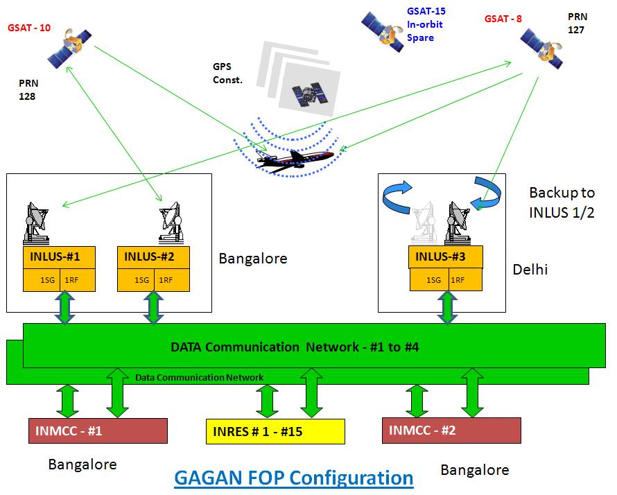
The Gagan satellite navigation system, developed by the Airports Authority of India (AAI) in collaboration with the Indian Space Research Organisation (ISRO), is a groundbreaking achievement for India in the realm of satellite technology. Gagan stands for GPS Aided GEO-Augmented Navigation and serves as a Satellite-Based Augmentation System (SBAS) that enhances the accuracy and reliability of GPS signals. This adaptive system is especially crucial for civil aviation and has transformed how pilots navigate through Indian airspace, allowing them to conduct approaches and landings with unprecedented precision.
Operational since 2015, Gagan has continually evolved, becoming particularly significant with its certification for the equatorial region in June 2026. It stands out as a beacon of technological self-reliance, reinforcing India’s position as a leader in GPS navigation technology. With its ability to provide real-time correction and integrity information, Gagan enhances flight safety by alerting pilots during navigation discrepancies, a necessity in ensuring the integrity of aviation operations.
Frequently Asked Questions
What is the Gagan satellite navigation system and how does it enhance GPS navigation technology in India?
The Gagan satellite navigation system, officially known as GPS-aided GEO augmented navigation, is India’s advanced satellite-based augmentation system (SBAS) that enhances the accuracy and reliability of GPS signals. Developed jointly by the Indian Space Research Organisation (ISRO) and the Airports Authority of India (AAI), Gagan provides real-time corrections and integrity information, which are crucial for safe navigation in aviation and other sectors. This system became operational in 2015 and uniquely positions India among a select group of countries with an operational SBAS, underscoring its commitment to technological self-reliance and leadership in satellite navigation.
| Key Point | Details |
|---|---|
| Certification of GAGAN | GAGAN is the first satellite-based augmentation system certified for the equatorial region. |
| Operational Since | GAGAN has been fully operational since 2015. |
| First Satellite-based Landing | India’s first satellite-based landing system approach was conducted on a commercial jet using GAGAN in June 2026. |
| Applications of GAGAN | Besides aviation, GAGAN is used in maritime navigation, telecommunications, and disaster management. |
| Advantages of GAGAN | Improves accuracy and reliability of GPS signals, providing real-time corrections and integrity information. |
| Support for Defense and Public Services | Strengthens navigation for defense operations and enhances efficiency of public services. |
| India’s Global Positioning | With GAGAN, India joins the US, Europe, and Japan in having an operational satellite-based augmentation system. |
Summary
The Gagan satellite navigation system represents a significant advancement in India’s aerospace capabilities, marking the country’s entry into an elite group of nations with operational satellite-based augmentation systems. Launched in collaboration with ISRO and AAI, Gagan not only ensures precise navigation for commercial aviation but also extends its benefits to sectors including maritime navigation and telecommunications. This multi-faceted utility and the system’s ability to provide high-accuracy GPS signal corrections underlines India’s commitment to becoming technologically self-reliant. As Gagan enhances public services and national defense, it underscores India’s pivotal role in the global navigation landscape.